Just some South Tyrol stuff:
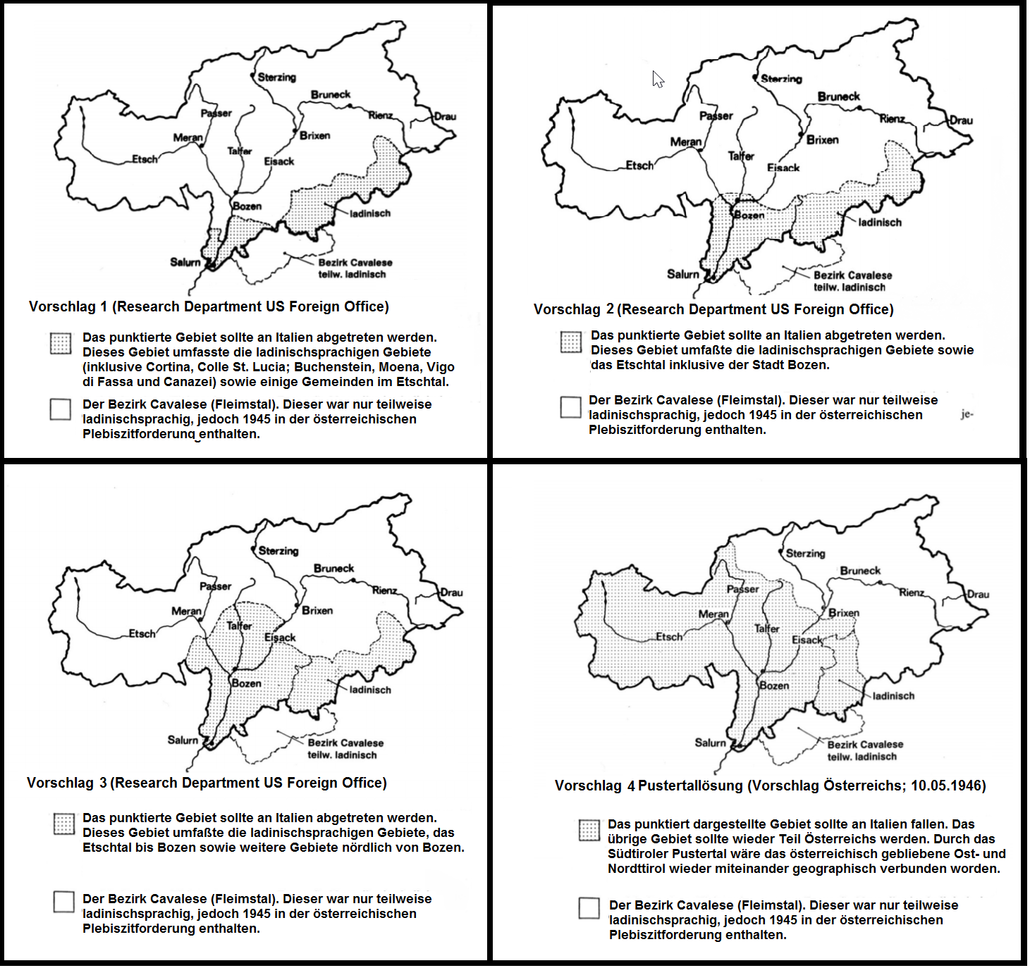
This map shows several partition proposals by the Research Department at the US Foreign Office and one Austrian proposal for South Tyrol after WW2. In each of these proposals the district of Cavalese in the province of Trento is marked because Austria also claimed it and requested it to be included in a plebiscite area together with the rest of the province of Bolzano, but none of these partition proposals would entail ceding it to Austria.
The first proposal would see the province of Bolzano returned to Austria, excluding the Ladin areas in the southeast and the southern tip of the Etschtal/Val d'Adige.
The second proposal is an expansion of the first, adding the town of Bozen/Bolzano to the territory to be retained by Italy and thus linking the southern Etschtal with the Ladin-speaking areas of the province.
The third proposal would've extended Italian control over the Etschtal even further.
The fourth proposal is an Austrian proposal to gain only the areas of the Pustertal, as well as the towns of Brixen and Sterzing, to Austria in order to connect the two Austrian portions of Tyrol with each other. Note how the fourth proposal would leave Austria with a small area that has a Ladin population.
The British meanwhile supported the idea of a plebiscite and in a
1946 House of Commons debate Sir Douglas Savory, member of parliament for the Queen's University of Belfast, stated:
"But it is not merely a question of the Pustertal, the valley which carries the railway to East Tyrol. It is a question of these three historic valleys—the Upper Etch, which the Italians call the Adige, the Eisack, which the Italians call the Isacco, and the Rienz. There is no claim put forward [...] for the Trentino, which is admitted to be Italian speaking. The point is that we want to restore the old historic frontier of Salurn, the linguistic boundary on the River Etch near the pass which is called the Salurner Klause—that is to say, the mountain pass of Salurn. The borderline which runs across the Brenner is not an ethnographic, and it is barely a strategic, frontier. The linguistic border coincides with the real strategic boundary—it is a magnificent boundary—which runs across the Ortler Mountain which is over 11,000 feet up, to the Marmolata over 10,000 feet. It is not only a borderline, but it is much more suitable for defence than the longer Brenner frontier [...]"
While that proposal is vague enough, it roughly equates to either the entire province of Bolzano or roughly speaking the first proposal by the US Foreign Office (possibly excluding the Ladin areas ceded to Italy).
Another member of parliament, Foreign Secretary Ernest Bevin, stated meanwhile in that session this about the negotiations about the original boundary post-WW1:
"Wilson proposed to put into Italy Merano, Bolzano, down the Pusterthal and right down to Albona in Venezia Giulia. That was the Wilson line, but after his discussions and at a later date—although he acknowledged, as I understand, that he regretted it—he did include the Brenner." This mirrors roughly proposal #4, and is described in more detail in an article written by one Charles Seymour in The Virginia Quarterly Review (Vol. 38, No. 4), where he describes "a line running between the linguistic frontier and that of the Brenner" which "would include within Italy such important centers as Bozen and Meran", while Klausen, Brixen and Toblach would be granted to Austria. I have found this map in the book "Im Schatten des Krieges" by Oswald Überegger which illustrates this, however it lacks some detail and the lack of post-1923 borders (when Cortina d'Ampezzo/Anpezo/Hayden was transferred to Belluno in Venetia) makes it harder to grasp IMO.